Translate

Guide to Patagonia's Monsters & Mysterious beings

I have written a book on this intriguing subject which has just been published.
In this blog I will post excerpts and other interesting texts on this fascinating subject.

Austin Whittall


Showing posts with label greek. Show all posts

Saturday, July 13, 2019

Homo Sapiens in Greece 210,000 years ago


This paper: Apidima Cave fossils provide earliest evidence of Homo sapiens in Eurasia published in Nature (Katerina Harvati et al., Nature (2019). DOI: 10.1038/s41586-019-1376-z) provides sound evidence that Homo Sapiens were living in Greece 210,000 years ago, which is 150 ky earlier than what had been considered as their arrival date in Europe.


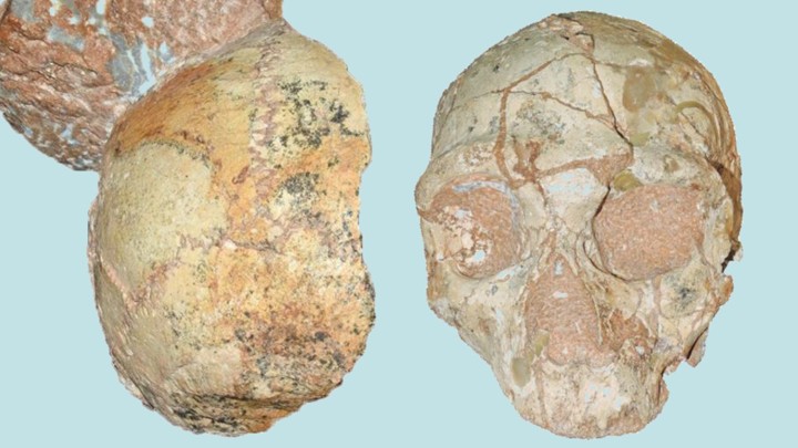
The cave of Apidima had two skulls, located side by side, roughly one foot apart (30 cm). One was identified as that of a Neanderthal, the other, a modern human skull.


Apidima Cave skulls, Homo sapiens (left) and Neanderthal (right).

The human skull is known as Apidima-1, and is definitively a H. sapiens skull based on its shape. It lacks the characteristic occipital bun that Neanderthals have.


The other skull, Apidima-2 is clearly a Neanderthal one. Its age is also correct -it was dated as being 170,000 years old- because Neanderthals lived in Europe at that time.


The paper summarizes its importance:


"Together, the Apidima crania suggest a complex pattern of population dispersal and possible replacement for southern Greece that is not dissimilar to that proposed for the Levant —a potential source area for the population represented by Apidima-1. In such a scenario, early modern humans who were present in the region in the late Middle Pleistocene were replaced by Neanderthals, whose subsequent pres-ence in southern Greece is well-documented. The latter were them-selves replaced by Upper Palaeolithic modern humans, whose earliest appearance in the region—as documented by Upper Palaeolithic lithic industries—dates to approximately 40ka."


The Apidima-1 skull is the oldest known modern human in Europe, and very likely in all of Eurasia. It is over 160,000 years older than the next oldest known European H. sapiens fossil.


The earliest Homo sapiens African remains -Africa is supposed to be the cradle of modern H. sapiens- date back to 315,000 years and were found in Morocco at Jebel Irhoud. Then come the Florisbad remains from South Africa at 260,000 years.


The skulls were washed into the cave in separate events 40,000 years apart, and stuck in the breccia, one foot apart until discovered in the 1970s.


This age of 210 ky is very close to the date assigned to another skull found in Greece, the Petralona crania dated at 160 - 240 kya yet belonging to a hominin which has been alternatively classified as being that of a Homo erectus, a Neanderthal and also a Homo heidelbergensis (ESR-dating of the fossil hominid cranium from Petralona Cave, Greece, G. J. Hennig, W. Herr, E. Weber & N. I. Xirotiris Nature volume 292, pages 533–536 (1981).


The dates are going back in time, and Sapiens in Eurasia is older than what a few years ago was deemed possible. Perhaps Homo sapiens fossils even older than those found in Africa are out there, waiting to be discovered.


Patagonian Monsters - Cryptozoology, Myths & legends in Patagonia Copyright 2009-2019 by Austin Whittall © 

Saturday, March 29, 2014

Ancient steel sword in Patagonia...


Ned Chace was an American sailor who disembaked in Patagonia and there between 1898 and 1929, working on the sheep ranches (Estancias) in Santa Cruz province, Argentina.


His adventures were recorded in a book, which was published in 1931, based on lengthy interviews with him, by the authors of the book, after his return to the U.S.


Below I transcribe one of his amusing tales (which is very likely true):


"He [Chace] found a big encampment site where the trail passed [lake] San Martin between Kachaik and Frank's [...] different from any modern Tehuelche encampment. It was fifty yards from water. He never found a modern toldo more than a few feet from water, even when the ground near it was wet. 'This had been an Indian campamento that had been there for years, I should say, and it had been a big one. Here in the center it'd all been covered about three feet deep with the loose sand and grass, and when the sheep come they cropped the grass, and the wind come and blew away the sand, leavin' a place where there'd been fires, for where the ground had been burned it was red, and there'd been stones in the fire heatin'. And off a ways, two or three hundred yards, you'd find where different Indians had had their tents around, and right in the center they evidently had that place where they'd all come to eat, settin' in a big circle. They had a fire in the middle, and then all these ostrich and guanaco bones where they broke 'em to dig the marrow out right there and threw 'em behind 'em. Them bones was old, old, old. I suppose they was preserved in the sand. And then you'd find arrow-heads, broken ones, it bein' I suppose where they took a broken one off to put on a new one. It was a great big circle, seventy-five foot across. [22.4 m]
Well, just off from this, there was a skeleton, right alongside a little fire where he'd died or been killed. The skeleton of a Christian with the legbones of a man that must have been about five foot six and of a very slender build, but he had an enormous forehead on him and a proper well-formed under jaw and a narrow face. And beside him there was a thin piece of steel about eighteen inches long, that looked like it might have been part of a rapier. That man'd never been buried. He was either killed by the Indians and left alongside where his tent had been, or he was killed in the tent and they took him outside. His bones was lyin' out just on a level with the fire, and they was Christian bones too you could tell they was different from Indian.'
He found a number of small encampment sites but never another big one." [1]


The map below shows the general area where Chace found this ancient native camp. The red arrows show the hill of Kachaik and Santiago (James) Frank's ranch, "La Federica", the area shaded in green along the shores of Lake San Martín marks the likely location of the native camp. In red, the "Antiguo Valle" and "Médano Norte" sites.


map of lake San Martin

Lake San Martín


First of all, let's get our bearings:


San Martín (named O'Higgins in Chile - both countries have this odd custom of giving different names to the lakes they share ) is a very large lake, shared by both countries: it has a surface area of 1,013 km2 (426 sq.mi.) of which 554 km2 are Chilean, and 459 km2, Argentine.


It is a low lying lake, barely 253 m above sea level (829 ft.), nestled among the high Andean peaks (+2,000 m - 6,550 ft.).


it is very deep: one of its arms, fjord-like O'Higgins arm is 836 m deep (2,741 ft.), making it the fifth deepest lake in the world. The others deeper lakes are: Lakes Baikal (1,741 m), Tanganika (1,471 m), Vostok (1,200 m) and the Caspian Sea (1,025 m).


The native Aonikenk Tehuleches called it Charre, which ment "Full". It was "discovered" by the Western world in 1877 by Argentine explorer Francisco "Perito" Moreno, who named it after Argentina's national hero General José de San Martín, whose armies marched from the Pampas, across the Andes into Chile, Peru and Bolivia during the independence wars against Spain (1812 - 1824). By the way, O'Higgins was his ally and colleague in arms in Chile.


It is a very irregular lake, with many long and narrow fjords, with steep sloped mountains towering over them; islands and Peninsulas mark its shores.


It receives the Mayer River on its northern arm and flows out, into the Pacific Ocean through the Pascua River. On the Chilean side of the border, the "Southern Ice Field" defines its southern coast, with great glaciers such as the O'Higgins Glacier which calve icebergs into it.


The southeastern coast, in Argentina, is barren, lacking trees. A muddy stream from Lake Tar flows into the lake's Chacabuco Arm.


It can be reached from Argentina's National Highway No. 40 from the village of Tres Lagos by Provincial Highway No. 31, a gravel surfaced road-track.


Kach Aike


Chace mentions "Kachaik": it is a very conspicuous hill, on the right hand side of Highway 31, which juts out several hundred meters above the surrounding flat steppe.


It towers 1,008 m high (3,304 ft.), and is the remains of an ancient volcano: it was formed when the soft rock of the volcano's conical slopes was eroded, leaving the tough basaltic rock that had solidified inside its chimney. The natives called the place:"Kach" = "ember" and "Aike" = "place".

The image below shows Kach Aike seen from the East, with the flat steppe and the lake behind it (the area where Chace found the native camp).


Kach aike

The "Ancient" natives


In Chace's story there are some interesting clues:


  • The camp was buried by 3 ft. (1 m) of sand, which he said was due to recent sheep activity after the arrival of settlers (late 1800s) which destroyed the grass and allowed the Patagonian winds to remove the loose sand under it, thus revealing the site.
  • "old, old, old" guanaco and ostrich bones.
  • Arrow-heads strewn over a circle 75 ft. diameter
  • It was a big and permanent camp quite far from the water 50 m (compared to contemporary Indian camps, which were very close to the water)
  • A slender built skeleton with a thin piece of steel 18 in long (45.7 cm), probably part of a rapier. Bones which were "different from Indian ... Christian bones"

People have inhabited this area since 11,100 BP right after the glaciers retreated. This was followed by a period during which it was uninhabited (7,600 - 5,600 BP). About 6,000 y BP the forest began at Chacabuco Peninsula, and the southeastern part of the lake was a grassland; then between 5,000 and 4,000 BP the area had more bushes and less grass. From about 4,000 and 3,000 BP a wetter period began, which lasted until about 100 years ago. During this period a grassy steppe covered the area [2]. This was the grass cropped by the sheep.


Some archaeological studies have been done in that area [2]: One spanned the flatland next to Katch Aike, a plain formed by the glaciers, between Highway 31 and the lake, at the Médano Margen norte (Northern Coast Dune) site. There they found lithic remains and guanaco bones in "four deflationary hollows" [deflation: where sand has been removed by the wind] "that covered an area of 345 m2" [quite in agreement with Chace's definition of a "cleared area" where the sand had been removed, and also its surface area: a circle with a diameter of 75 ft. covers 410 m2].


Another site was found at "antiguo Valle" (Old Valley), to the nortwest, where the remains covered a surface of 600 m2.


In the map above I have shaded in green, the area where this campsite may have been located. It was 50 yards from the lake, Chace makes a point in saying that contemporary Indians never camped so far from water. The greater distance may either indicate that the natives were not of the same group as the then extant Tehuelche natives or, that the lake level dropped moving the shore further away from the site during the period of time that has elapsed since the natives camped there. I have not found any evidence that the lake's water level has dropped, but I will keep on looking for it.


The datings of occupations at some caves close by date back to 4,760 BP, and at Lake San Martin (Kach Aike) and Lake Tar, there are late Holocene dates (2,500 BP).


Interestingly, "protected places like the dunes, had been occupied all year round... added to this is that access to lithic raw materials would have been relatively easy..." [2]. Which agrees with Chace's comment of a large encampment that had been there for years (it was in fact a year round camp and would be large and have plenty of tents) and the manufacture of arrow heads.


The date 2,500 BP for the site makes it unlikely that the remains described by Chace be those of a "Christian". So, to whom did they belong?


Ancient Mariners...


Since Native Americans did not know how to produce steel or iron tools, the owner of the 18 inch rapier 500 years BC, must have come from some steel making culture from Europe or Asia.


I am reluctant to pronunce myself in favor of a Phoenician, Greek or Carthaginian because I am not sure if they made steel swords (they made them of iron). Of course, Chace may have mistaken iron for steel, in which case the owner could have belonged to any of those cultures.


Steel, is iron with a certain -very low- content of carbon. The resulting alloy is more flexible than iron and does not shatter upon impact. It was not easy to make, and very valuable.


How did this person get there?


Lake San Martín is quite inaccesible from the West: a shipwrecked sailor on the South Pacific coast of Chile would have to walk along the northern edge of the Sothern Ice Field, up the dense forests of the Pascua River and then after reaching the lake, sail its choppy waters to its Eastern coast (or walk through a terribly dense forest with sheer sloped mountains). The terrain is so bad that even today there is no road linking the Chilean town of Villa O'Higgins on the north tip of the lake with the Argentine side of the border.


From the Atlantic, the lake can be reached either from the mouth of the Santa Cruz River or from San Julián inlet by following the Chico or Sheuen River to its sources and then, across the divide to lake Tar and along Tar river till reaching Lake San Martín.


The fact that it is a rapier (thin and narrow sword) and made of steel may even make it possible that its owner was a Spaniard, from the XVIth century. In which case the date is wrong, instead of 2,500 BP, it should read 500 BP.

This was an area beyond civilization, Spain never colonized or conquered Patagonia, so the Spaniard may have been a survivor of one of the many shipwrecks along the Strait of Magellan or even from the ill-fated towns founded on the Strait by Sarmiento de Gamboa in the late 1570s.


Maybe the unfortunate man walked north, seeking the Spanish settlement on Chiloé Island, marching close to what is now the border between Chile and Argentina, on the edge of the forests, going around Lakes Argentino and Viedma, and then following the native path towards Lake San Martín, where exposure, hunger, illness or maybe a band of natives, ended his pain.


This last theory (the "trekking Spaniards") is not as crazy as it seems: in 1563 two Spaniards (Pedro de Obiedo and Antonio de Cobos) arrived at Concepción, Chile in northern Patagonia. They swore that they were sailors of a ship that sunk in the Strait of Magellan in 1540, part of the Bishop of Placencia's fleet [3]. They reported that the stranded crew had marched north, confronted the Indians that attacked them, found a secluded spot and set up a fort. They later lived in peace with the Natives. This was the mythical Lost "City of Ceasars". However Obiedo and Cobos committed a crime and fled north to escape punishment, walking all the way to the Spanish town of Concepción.


There are other instances of shipwrecked sailors: Juan Ladrillero's expedition (1558) capsized in the Strait of Magellan and all were lost except for Lardrillero and a sailor who "with notable courage and perseverance walked along the slopes of the mountain range, beating infinite difficulties and continuous risks to their lives, reaching Valdivia [in Northern Patagonia] after one year and four months" [6]. (Quite a long walk indeed!).


Sailors from English, Dutch and even American ships (after 1776) ships were also shipwrecked along Patagonian shores: Darwin reported castaways rescued during the voyage of the Beagle, close to Chiloé Island [4], and Wager was stranded on an island for weeks until the natives helped the survivors of his group to reach Chiloe. [5]


Sources


[1] Robert and Katharine Barrett, (1931), A Yankee in Patagonia, Edward Chace Houghton Mifflin Co. 1931. pp. 91-92
[2] Espinosa S, Belardi J, Barrientos G and Carballo Marina F. (2013), Poblamiento e intensidad de uso del espacio en la Cuenca del lago San Martin (Patagonia Argentina): nuevos datos desde la margen norte. Comechingonia vol.17 no.1 Córdoba jun. 2013.
[3] Patricio Estellé and Ricardo Couyoudmdjian, (1968). La Ciudad de los Cesares: Origen y Evolución de una leyenda (1526-1880). Historia, No. 7, Instituto de Historia. Univ. Cat. de Chile. 283-309.
[4] Darwin, C., (1987). The Voyage of the Beagle. Ware: Woodsworth Editions.
[5] Gurney, A., [Ed.], (2004). The Loss of the Wager: The Narratives of John Bulkeley and the Hon. John Byron. Woodbridge: Boydell Press.
[6] de Rosales, D., (1666) Historia General del Reyno de Chile Ed. 1877, Imp. El Mercurio., Vol. 1. pp. 84


Patagonian Monsters - Cryptozoology, Myths & legends in Patagonia Copyright 2009-2014 by Austin Whittall © 

Wednesday, February 19, 2014

On Amerindian HLA, Phoenicians, Neanderthals and Paracas mummies


Continuing my quest into the possible early peopling of America by Neanderthals, I have come across an interesting paper by James Guthrie (2001) [1] on Human Leukocyte Antigens (HLA).


In a previous post, I wrote the following:


Human leukocyte antigen (HLA) system
HLA are the loci of genes which encode for major histocompatibility complex (MHC) in humans and as such have an important role in the immune system. Ten Neanderthal HLA class I alleles have been found among humans: A*02, A*26, A*66, B*51:01/08, B*07:02/03/06, C*16:02, C*07:02.
Of these, two are found among Native Americans: The paired alleles A*02 and C*07:02. While their average global frequency is approx. 2% , the highest global frequency occurs among the Yucpa of Venezuela (26.9%), followed by Navajo, US (13.1%) and Lisu, Yunan, China (10.4%).
The high frequency in America and China is consonant with the high proportion of Neanderthal admixture in those regions.


Guthrie's paper deals with Native American HLA and mentions one of those "Neanderthal HLA alleles", the A*02 (bold is mine):


Distributions of these ten HLAs in other parts of the world are not what would be expected from the premise that Americans stem mainly from Northeast Asians. Instead, the basic American populations seem most like those of western Asia and of Southeast Asia, paralleling the findings of Steele and Powell (1992) regarding Paleo-Indian skulls. Their multivariate analysis showed craniofacial features closer to those of southern Asians and Europeans than to those of northern Asians. The only HLA prominent in both America and northern Asia is A*2, which CS call ubiquitous and which is also strong throughout Europe, South China, and Japan... [1]


The A*2 prevalence in Europe and China is evidently due to their closeness to Neanderthals.


The resemblance of Amerindians to Western Asians is also supported by the genome sequenced from a 24 Kya H. sapiens (named MA-1) from Mal’ta in south-central Siberia:


  • It suggests that between 14 to 38% of Native American autosomal ancestry originated through a gene flow from this population.
  • MA-1 is closer to contemporary Native Americans than to Northeast Asians suggesting that those groups may have originated in secondary wave(s) of immigrants from East Asia [2], or that back-migrations from America dispersed other lineages in Central and Western Eurasia [3].
  • Ma-1’s estimated shared drift statistic, (f3), places Amerindians closest to Northern Europeans and Northern - Central and Western Siberians, and furthest apart from Eastern Siberians and Asians. Possibly indicating a common Neanderthal background, which could explain the European signature found in pre-Hispanic Amerindians (i.e. Kennewick man).

The Phoenician connection


Guthrie's paper also deals with other HLAs, with interesting inferences:


The A*32 allele seems to indicate a Mediterranean or specifically Aegean impact in the Caribbean region (including on the Cherokee) as well as on Tupians of the lower Amazon (Oyampí and Parakana). It seems to connect this set and the Central Amerind composite with northern India, Sardinia, the Tuareg of Algeria, and with populations around the Adriatic Sea in Greece, Yugoslavia, and Italy. A*32 is absent from other South American samples except the Mapuche.
A*32 levels in the Mapuche, Oyampí, and the Central Amerind composite samples are among the top nine in the CS tabulation (7-9%), and the Tupian Oyampí near the mouth of the Amazon River have the second highest American frequency. If this is not an artifact of sampling [...]
Both A*32 and A*30 are found at significant levels in Greece, Sardinia, and in the Central Amerind composite. They also appear at anomalously high frequencies in Samoan outliers but are not documented elsewhere in Pacific islands. This may reflect limited exploration of the Pacific by Mediterraneans who otherwise left few traces except (controversial) petroglyphs. [1]


Curiously this may be an indication of Phoenician, Cretan, Mycenean or Carthaginian genes during their sea voyages beyond Gibraltar. (See my many posts on Phoenicians in America).


No Paracas HLA data


Online sources cite Guthrie as having proven that Paracas mummies HLA is European. This is false. Check his only comment on Paracas Mummies below:


European Genes from other Systems
There may be no clear marker for European ancestry among the “classical” genetic variants, although a high frequency of the Rhesus cde (r) allele might qualify. CS [Cavalli-Sforza] also considered immunoglobin f;b, adenylate kinase 1, and ABO type B, when found together, to indicate Caucasoid admixture in eastern North America (p. 337). Occurrences among indigenous Americans of cde or A or B of the ABO system were once attributed to recent admixture and databases were “corrected” accordingly. It is now understood that some of these unexpected alleles arrived in antiquity. Mummies from Paracas, Peru, possessed both A and B antigens (Allison et al. 1976, 1978). [1]


So he does not mention HLAs, only Blood groups and the fact that Paracas Mummies had A and B antigens. Which does not mean that they were Europeans.


Sources


[1] James L. Guthrie, (2001). Human Lymphocyte Antigens: Apparent Afro-Asiatic, Southern Asian, & European HLAs in Indigenous American Populations Pre-Columbiana, Volume 2, Number 2 & 3, December 2000 & June 2001 (online at New England Antiquities Research Association
[2] Raghavan M., Pontus Skoglund P., et al., (2013). Upper Palaeolithic Siberian genome reveals dual ancestry of Native Americans. Nature 505, 87–91 (02 Jan 2014) doi:10.1038/nature12736
[3] Dziebel, G., (2013). The Demographic Isolation of Amerindians and Back Migrations to the Old World in the Late Pleistocene/Early Holocene: From the History of Ideas to Contemporary Scientific Realities. Paleoamerican Odyssey Conference in Santa Fe, New Mexico 17 Oct. 2013


Patagonian Monsters - Cryptozoology, Myths & legends in Patagonia Copyright 2009-2014 by Austin Whittall © 

Thursday, March 3, 2011

Ancient Greeks in the River Plate!

 
Map showing the location of Dolores, Uruguay, site of the "Greek" remains.
Copyright © 20011 by Austin Whittall


This post is about a farmer who, in the early 1800s, lived close to the Uruguayan town of Dolores. He made an amazing finding: an inscribed stone and some ancient body armor, which was supposedly identified as belonging to a Greek explorer from the days of Alexander the Great. This story, sounds like a hoax, but since I have been posting on Phoenicians in America, I thought, ok why not! So here it is:

The original text is worth quoting from its source (a local magazine published in Soriano, the Uruguayan District where Dolores is located), a 1963 article:

A farmer [...] had discovered an ancient stone, sunk in the ground, on which some unknown letters were written. Picking up the stone, he came across a small stone chamber , inside of which were two very ancient swords, a helmet and a shield, very rusty, and a regular sized amphora. He took those pieces to Montevideo, and the priest Martínez managed to decipher the coarse and worn greek characters, whose translation was: "During the reign of Alexander king of Macedonia, son of Phillip, on the 63 olympics, here Ptolemy...", the rest of the phrase could not be read. On the hilt of one of the swords, whose blades were completely destroyed, a relief with the head of Alexander could be made out. The helmet still displayed a delicate work of metal craftmanship, representing in relief Aquiles dragging Hector's body around Troy. [1]

The sources

Text about Ptolemy, the "Greek" from 320 BC whose remains were found in Uruguay. From [1].


The above text was originally published in 1835 in the Montevideo newspaper "El Universal", who in turn took it from the December 9, 1934 issue of the "Jornal do Comercio" of Rio de Janeiro. The Brazilian journal informed that it had got the news from the "Gaceta de Francia" of Paris, which had taken it from the "Le Temps" of April 11, 1832, and this paper from the "Messager des Chambres " of March 22, 1832.

The article seems to have been published before that date in the "Giornale del Regno delle Due Sicilie" on June 11, 1829 and before that, in the "Gaceta Universal" of Bogotá Colombia.

Criticism and comments

The first flaw found in the story was the date. The 63rd Olympic games took place around 528 - 524 BC, long before Alexander's regin (Alexander died in 323 BC).

However, if instead of 63, you read 113, the Olympic games date would fit neatly within Alexander's reign over Macedonia and most of the "known" world.

The thing is that at the time (1829) Uruguay was just coming out of a war against Brazil, in which it won its independence (with the help of Argentina), and political turmoil would have covered up the news, which was disclosed through a distant paper in Colombia instead of locally, in Montevideo.

What would a Greek ship be doing at Dolores? In those days, the delta of the Paraná River was several tens of kilometers up stream from its current position just 20 km (12.5 mi.) north of Buenos Aires.

The delta advances at about 25 to 100 m/year (82 to 328 ft/year),[2] so over the last 2,320 years it would have been located between 58 and 232 km further north (36 to 144 mi.), upstream. See the map below.

The Uruguay River lacks a delta and drains into the eastern side of the River Plate as a wide river.

Dolores, the site of the finding, is located on the San Salvador River which drains into the Uruguay River. Perhaps it offered a good port for the Greek sailors. Actually, Sebastian Cabot, the first to explore the region after Magellan and Solis, actually built a fort on the mouth of the San Salvador. He must have chosen it for some strategic reason. This fort is the first Spanish settlement in Uruguay (1527). He would later sail up the Paraná and establish Sancti Spiritus at Carcaraña, Argentina.

Could the Greek soldier be a dead member of Cabot's expedition?

Map showing coastline in 320 BC with the possible maximum and minimum area covered by water. This area in now occupied by the Delta of the Paraná River.
Copyright © 20011 by Austin Whittall


The map above shows the maximum and minimum extent of the River Plate in the days of Alexander the Great. The delta did not extend beyond Rosario or Zarate based on the max. and min. advance of the delta (58 and 232 km) mentioned above.

Sources.

[1] Un Enigma histórico. Ptolomeo fue enterrado en Dolores. Revista Histórica de soriano. May 31, 1963. No. 8. pp. 8.
[2] Marcos Pittau, Alejo Sarubbi, Angel N. Menéndez Analisis del avance del frente del delta del rio Parana


Patagonian Monsters - Cryptozoology, Myths & legends in Patagonia
2011 International Year of Forests
2011 International Year of Forests Copyright 2009-2011 by Austin Whittall © 
Hits since Sept. 2009:
Copyright © 2009-2025 by Austin Victor Whittall.
Todos los derechos reservados por Austin Whittall para esta edición en idioma español y / o inglés. No se permite la reproducción parcial o total, el almacenamiento, el alquiler, la transmisión o la transformación de este libro, en cualquier forma o por cualquier medio, sea electrónico o mecánico, mediante fotocopias, digitalización u otros métodos, sin el permiso previo y escrito del autor, excepto por un periodista, quien puede tomar cortos pasajes para ser usados en un comentario sobre esta obra para ser publicado en una revista o periódico. Su infracción está penada por las leyes 11.723 y 25.446.

All rights reserved. No part of this publication may be reproduced, stored in a retrieval system, or transmitted in any form or by any means - electronic, mechanical, photocopy, recording, or any other - except for brief quotations in printed reviews, without prior written permission from the author, except for the inclusion of brief quotations in a review.

Please read our Terms and Conditions and Privacy Policy before accessing this blog.

Terms & Conditions | Privacy Policy

Patagonian Monsters - https://patagoniamonsters.blogspot.com/