My last posts have dealt with a Brazilian geologist and Archaeologist, Maria Beltrão. She has proposed that our distant relative, the H. erectus reached America over 1 million years ago. Below I post about her and the route she proposes for this migration of H. erectus into America.
Beltrão writes about herself
Beltrão points out in an article [1] that hominids have been living in Asia at least since 1.8 million years ago (in Indonesia, central China and Pakistan), and also in Georgia, (the remains are probably anHomo habilis), with this in mind, she adds:
“If over 5 million years ago, animals crossed from Asia to America and vice versa, man, being a hunter why did he say “no” to America and did not follow his prey during the last 2 or 4 million years?”[1]
As a geologist, she has sought out sites whose surface is sealed off, either with marl as at Toca da Esperança, or with lava as at Itaboraí, to ensure undisturbed layers.
The South African gateway
She proposed (together with Paepe, 1978 - I have not been able to find the paper / article) a migration from South Africa to South America during the glacial period, crossing the ice pack.
This is an interesting “Out of Africa” route, it must go south, cross the sea between South Africa and the ice pack surrounding the Antarctic, then go along the pack’s coastline till it reaches America and from there, back up, into Patagonia. A long and risky journey that combines sailing and trekking along the ice pack.
I have posted about a possible route via the Antarctic into South America, but from the West, from Australia, New Zealand and Tasmania. An equally difficult and longer route than the South African one.
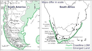
To get an idea of what would have to be trekked – sailed – navigated, I combined two different maps that depict the coastline of Southern Africa and the Southern part of South America during the Last Glacial Maximum (LGM), when most of the water was stashed away in the form of gigantic ice sheets covering the Northern Hemisphere, Antarctica and parts of South America and New Zealand. The sea level dropped and exposed parts of the continental shelves of both continents (shaded in light green). The sources of the maps are [2] and [3]. I also added another map taken from[4], and adapted from its FIG. 5. Which shows the ice thickness in meters (filled color contours) winter during the LGM. South Africa not included in the original map, was added by me. The red arrow shows the possible land and sea route that could be used to reach America from Africa.
I am well aware that our friend, the H. erectus would have reached America long before the last Ice Age and its LGM, yet even so, I chose the LGM coastline for two reasons: one, that all previous glaciations would have provoked a similar drop in sea level and, two, that I could not find any data on previous glaciation coastlines.
Below are the maps:
I believe that the circumpolar current flows from West to East and therefore would hinder a direct navigation across the South Atlantic. But I must check to see if this is valid for glacial periods.
Sources
[1] Maria Beltrão, (2008). Depoimentos de Arqueólogos pioneiros: Maria Beltrão, ISSN 1807-1783, atualizado em 02 de abril de 2008. História e-História
[2] C.Leigh Broadhursta et al, (2002). Brain-specific lipids from marine, lacustrine, or terrestrial food resources: potential impact on early African Homo sapiens . Comparative Biochemistry and Physiology Part B: Biochemistry and Molecular Biology. Volume 131, Issue 4, April 2002, Pages 653–673
[3] L. Miotti and M.C. Salemme, (2003), When Patagonia was colonized: people mobility at high latitudes during Pleistocene/Holocene transition. Quaternary International. Volumes 109–110, 2003, Pages 95–111
[4] Otto-Bliesner, et al, (2006). Last Glacial Maximum and Holocene Climate in CCSM3 J. Climate, 19, 2526–2544. doi: http://dx.doi.org/10.1175/JCLI3748.1
Patagonian Monsters - Cryptozoology, Myths & legends in Patagonia Copyright 2009-2012 by Austin Whittall ©


According to paleo ice records, there was a nice warm spell around 320-300,000 b.p. for Erectus/Heidelbergensis to become cold adapted to the asian arctic, and then be in place when sea levels dropped during the next cold period to cross Beringia in time to get to Valsequillo 280,000 bp, or SA in time for the old dates there.
ReplyDeleteWilliam Dansie