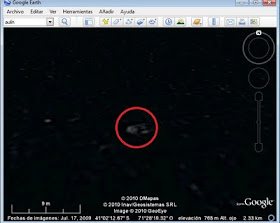
Odd shape in Lake Nahuel Huapi. Google Earth
Above is a screenshot from Google Earth. The coordinates of the white blob inside the red circle are given in the image. It is a spot in the middle of the lake, between Huemul Peninsula and San Pedro Peninsula, just east of Victoria Island.
It is about 8 m (25 ft.) long and big enough to appear in the satellite photograph.
What is it? Jokingly I could say it is Nahuelito. But it is more likely a train of waves which, in that part of the lake can be quite big on a windy day. Frothy rolling waves may appear on a satellite image. However the shape is odd. Could it be a boat? (not too clear an image to let us decide if it is or it isn't). It could also be a burst of bubbles issuing from the fault that lies below, on the lake's bed (see my post Bubbles and Nahuelito).
Patagonian Monsters - Cryptozoology, Myths & legends in Patagonia2011 International Year of Forests Copyright 2009-2011 by Austin Whittall ©


No comments:
Post a Comment